
Kory VanDyke, undergraduate Geography major, spent his summer mapping out a youth camp in the Cascades by gathering GIS data in the field as well as utilizing secondary data online. Here is what Kory has to say about his experience:
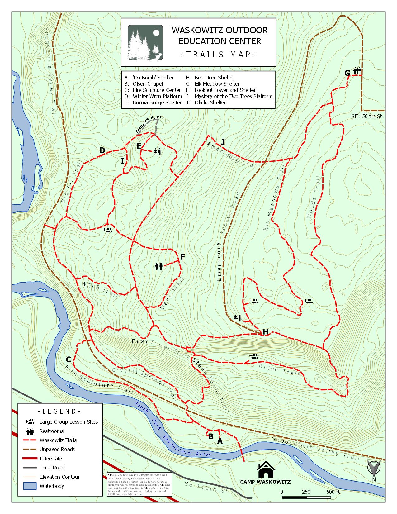
Over the summer, I got the opportunity to create some maps for a youth camp near North Bend called Camp Waskowitz. This map-making experience was unique in that it had me not only using secondary GIS data available online but also collecting primary data by physically walking the trails and logging GPS coordinates to represent them. This gave me the unique experience of mapping in the real physical environment, which is something that I think we have grown out of now that technology and secondary data is more accessible. The ability to physically experience the map as we’re creating it, can help us to create a more functional map for the intended user.
Before walking each trail, I thought I could make it easier on myself by creating a preliminary map based on what I could observe using satellite imagery from Google combined with shapefiles available on the King County GIS data website. The data I collected online from these sources provided more than enough information about the trails and the area around the camp. I figured this map would be simple enough by just combining the primary data I’d collect of the trails with the secondary data and in no time I’d have a decent map. Little did I know that my understanding of the map would change once I experienced it.
If the trails data was already provided to me and I simply had to create a map with it this would have probably given any user a negative experience in trying to navigate the trails. I quickly learned this firsthand as I underestimated the trails trying to use the outdated map I was tasked to recreate. The sense of scale was hard to follow which distorted the actual length of trails and the topography was absent which made the steep hills unexpected. A mid-morning hike was beginning to feel like a full work out for an adult and, yet, I was tasked with creating a map that would make it easier to navigate for children.
Experiencing the map for myself helped me learn a number of things I wouldn’t have learned by simply using my computer and never visiting the site in person:
- Google Maps can be wrong. – What was labeled as a street behind the trails of Camp Waskowitz was nothing more than a dirt path with no discernable street signs. What looked like an extension of the trail turned out to be powerlines cutting through the vegetation.
- Conventionality is not always right. – The map that I was recreating was designed with the conventional north arrow pointing up, but this was incredibly confusing trying to orient myself properly on the trails. My coordinator from the camp agreed that it didn’t make sense to orient the map north if we were walking due south away from camp.
- Nature is not easy to map. – The map I was using did not warn me about the overgrown thorn bushes that scraped my legs, slowing my progress or the giant felled fir tree that rerouted the trail. Seeing things first hand let me know that this map was to be dynamic and had to compensate for changes in nature.
My take away from this is that it’s important to remember, as geographers, that the maps we are creating are real places. Somebody is going to use the map you create to help them when they experience the map for themselves. So try to experience your own map before you create it.