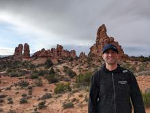
Since graduating from UW with a B.A. in Geography and History in 2005, Mike Mamic has followed a relatively straightforward path in the GIS career field. First, he began as a GIS Intern with the City of Puyallup. After that, Mike worked as a GIS Technician for Wahkiakum County, Washington, for two years before moving to Bend, Oregon. From 2008 to 2018, Mike served as the Chief GIS Cadastral Cartographer for Jefferson County, Oregon. Now, for the past six years, Mike has been working as a GIS Analyst with Deschutes County.
Here, Mike shares more insights gleaned along the way, from UW to Deschutes County and beyond!
A "Day in the Life" as a GIS Analyst
Working as a GIS Analyst in the IT department places me at the center of GIS operations within the county. We manage a vast amount of data, which is updated daily through numerous Python scripts, and I oversee this process to ensure data accuracy and efficiency. Additionally, I collaborate with multiple departments that lack in-house GIS resources, providing support and solutions tailored to their needs.
GIS is fundamentally about sharing data, and a significant part of my role involves developing internal and external web mapping applications and conducting spatial analysis across various county departments. My projects range in scale, from small daily project to large, impactful projects. One of the most significant projects I’ve undertaken is the creation of a real-time fire evacuation application. This tool serves as an internal staging app and, through geoprocessing widgets, is also shared publicly. You can visit the application here:
Fire Evacuation App
Rather than focusing on a single task or project, my work spans across multiple departments. This variety keeps my role dynamic, ensuring that no two days are the same and making the work both engaging and rewarding.
Likes and Dislikes
It’s hard to sum this up in just a few sentences! What I enjoy most is continuously improving my GIS skills, whether it’s writing code to streamline tasks or developing new abilities like reporting to expand my capabilities. Throughout my career, I’ve been fortunate to pick up a wide range of skills that have strengthened my resume. From reading legal descriptions and COGO’ing property lines to implementing security practices on a GIS server- and everything in between - I love the variety and constant learning that comes with my role.
What I dislike most? Meetings! Most of them could easily be handled through Microsoft Teams chats or emails.
Connections Between UW Geography and Career
Studying geography has had a major impact on my career, especially learning how to use ArcGIS Desktop. It was one of the most valuable skills I gained, equipping me with the ability to work with maps and data to solve problems—something I rely on daily in my job. Another key experience was spending time in the computer lab with classmates. Collaborating, brainstorming, and exchanging ideas not only strengthened my technical skills but also built my teamwork abilities. Today, much of my work involves working with colleagues to find solutions, and those experiences prepared me well for that aspect of my career.
Advice for Current Students
Go for it! In the last 20 years since I graduated, the GIS field keeps growing at the same pace as technology. I spent my whole career in the public sector, but, there are private sector jobs all over. Do not be afraid to move away from your comfort zone. And, don’t be discouraged! After graduating it took me a while to land my first GIS job. When I did, I ended up moving 2-plus hours away from my comfort zone knowing that this first job will jumpstart my career. Get that experience and learn along the way!
